 |
| burning just east of the PV campground. You can see a fire crew just left of the smoke (and a good bit farther away) |
 |
| from the same position with the 14mm lens the smoke obscures the sun (3pm) |
That afternoon the fire burned east along the river bed fanned by a gusty wind from the west and NW. The wind was forecast to switch to more out of the north which would have been bad for Bishop. They ordered an evacuation of pretty much everything in the area N of highway 395 and W of Hwy 6. Later I think they evacuated Laws too since that is the direction things were headed.
Once it got dark you could see the lit up smoke from town.
 |
| viewed from town (my front yard) the road runs N/S (7:49 pm) |
I drove out west of town along Red Hill Rd where I had a bit of elevation to look down towards the fire (but I wouldn't be downwind like I would if I went out to the foothills of the White Mtns).
 |
| wider angle view from Red Hill Rd (9:06 pm) |
You could see flames maybe along the canal heading SE off the Owens R across from the Happy Boulders and the main front appeared to be near the Five Bridges bridge over the Owens. There were what appeared to be entire trees engulfed in flames as well as at least a few wooden power poles burning. There were also a lot of blinking lights from the firefighting crews along what I think was 5 Bridges Road. (Cal Fire reported 20 crews with 50 vehicles and 4 dozers and 400 personnel worked the fire). I imagine that there wasn't a whole lot that could be done with some of the gusty winds. Thanks for all of your hard work firefighters.
 |
| fire front from Red Hill Rd (fire crossing 5 Bridges Rd?) I suspect all the parked cars in the lower right are on 5 Bridges Rd. (9:11 pm) |
 |
| zoomed in on the previous photo, note burning telephone pole and trees. |
By the time I left Red Hill Rd around 9:20 the fire front was quite a bit farther east.
 |
| 11 minutes later the fire has moved quite a bit the trees near the right of the previous picture are in the center of this one (9:21 pm) |
 |
| zoomed in on the previous picture |
From the N end of 2nd street I could possibly see an occasional flame but for sure the fire had moved a lot farther east.
 |
| view NNNE across the park towards the fire (9:58 pm) |
The next morning things were much more calm and there was no obvious smoke plume. The webcam above Silver Canyon shows what burned fairly clearly.
Cal Fire originally reported 2,800 acres burned but reduced that to 2,250 after more careful mapping. they said it started at 2:12 pm the 18th. By noon the 19th they report 15% containment. It does not appear to be spreading, although with a fairly strong cold N wind any hot spot flare up could be bad for Bishop.
It appears that people will be able to return to most of the evacuated areas at 3 pm the 19th.
Over the next few days they gradually increased the % contained and fixed at least some of the downed poles and lines (power was restored to at least some of the areas effected). They also reduced the area burned to 2,070 acres. The roads were opened Friday evening I think and I drove in Saturday to boulder and take some pics.
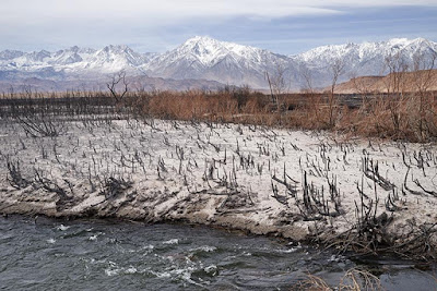
Some areas were really burned hard while others were barely touched. I suspect it will be very green later in the spring, especially if we get any precipitation. Some of the willows along the river were completely burned but many were not. It will probably spread back from this patchwork fairly quickly (in a few years anyway). Meanwhile the packrafting and maybe even SUPing down this section might be a bit better since it was getting choked by branches hanging over the river.
 |
| Owens river just below where a canal comes off to go to Fish Slough - this area burned pretty completely, but there are living willows nearby |
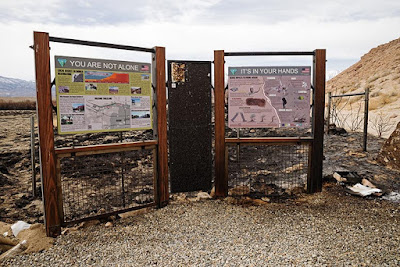
The fire was not close to the lower Sad Boulders parking. The fire was right up to and across the fence by the Happy Boulders parking. The sign at the end of the parking area was a bit singed but held up well, the dog crap bag dispenser was burned away. Perhaps this will decrease the number of bags of dog crap all through the boulders and along the trails? One can hope, but I think it unlikely. I only saw 4 today though.
 |
| singed information kiosk at the Happy Boulders parking - on the right is the bag dispenser |
 |
| looking down at the end of the Happy parking note some of the willows did not burn |
